Satellite Data Debunks Climate Change Denial: 2023 Was the Hottest Year on Record
Although climate change has long been a subject of great debate and nature keeps surprising us with various anomalies, this phenomenon is still often questioned or even denied. Dr Laurynas Jukna and Dr Elzė Buslavičiūtė, geographers at the Faculty of Chemistry and Geosciences of Vilnius University (VU), who apply remote sensing to monitor the Earth’s surface for their research, have explained what climate change evidence can be revealed by satellite data and how global warming has affected glaciers.
2023 – the year of record heat temperatures
Satellites play an important role in monitoring global changes on the Earth’s surface. Since the launch of the first weather satellite – Vanguard 2 – in 1959, such space-based observations have become a crucial part of climate research. According to the geographers, this was the first time in human history that we could cover such vast areas and observe the entire planet. Today, 50 years since the onset of the remote sensing era, the accumulated amount of data allows us to track long-term trends and draw major conclusions about the effects of anthropogenic climate change, i.e. caused by human activity.
At the end of the year, the Copernicus Climate Change Service, headed by the European Commission, announced 2023 as the warmest year on record, surpassing the previous highest levels observed in 2016 and marking a 1.46°C spike in the average global temperature from pre-industrial levels. According to the World Meteorological Organization, greenhouse gas levels in 2023 continued to increase, the global average sea level rose, and the average daily sea surface temperature reached a record high.
When assessing the effects of anthropogenic climate change, scientists are keeping a close eye on the Arctic and Antarctic Circles. Arctic temperatures are rising two to three times faster compared to the global average. This phenomenon, known as Arctic (or polar) amplification, is likely to be at least partly determined by the reduced surface albedo, as melting sea ice exposes darker (absorbing more solar radiation) seawater beneath it. While, over the past decade, several other factors have also been proposed to explain potential causes of such amplification, one thing is clear: the North and South Poles are continuing to warm up along with the rise in fires, heavy rainfalls, droughts, and other extreme weather events.
The Arctic’s record-hot summer and melting ice
The National Oceanic and Atmospheric Administration (NOAA) has recently announced that summer surface air temperatures during 2023 were the warmest ever observed in the Arctic, while Arctic sea ice reached its sixth-lowest minimum extent in the 45-year satellite record. According to Dr Buslavičiūtė, this data is registered by radiometers: ‘Microwave radiometers are among the most commonly used satellites for sea ice measurements, and belong to the group of passive sensors as they only record thermally-emitted electromagnetic radiation rather than emit it themselves.’
Based on different brightness temperatures of seawater and sea ice, such sensors can help determine sea ice extent. In addition to these measurements, radiometers are also used for the remote sensing of wind speed, water vapour content, soil moisture, and snow depth.
NASA has been archiving passive radiometer data on sea ice since 1979. The Arctic sea ice extent minimum recorded in 2023 was the sixth lowest in 45 years of observations. Over the past 17 years (2007–2023), 17 Arctic sea ice minimum extents have also been measured, mostly during the periods from September to October.
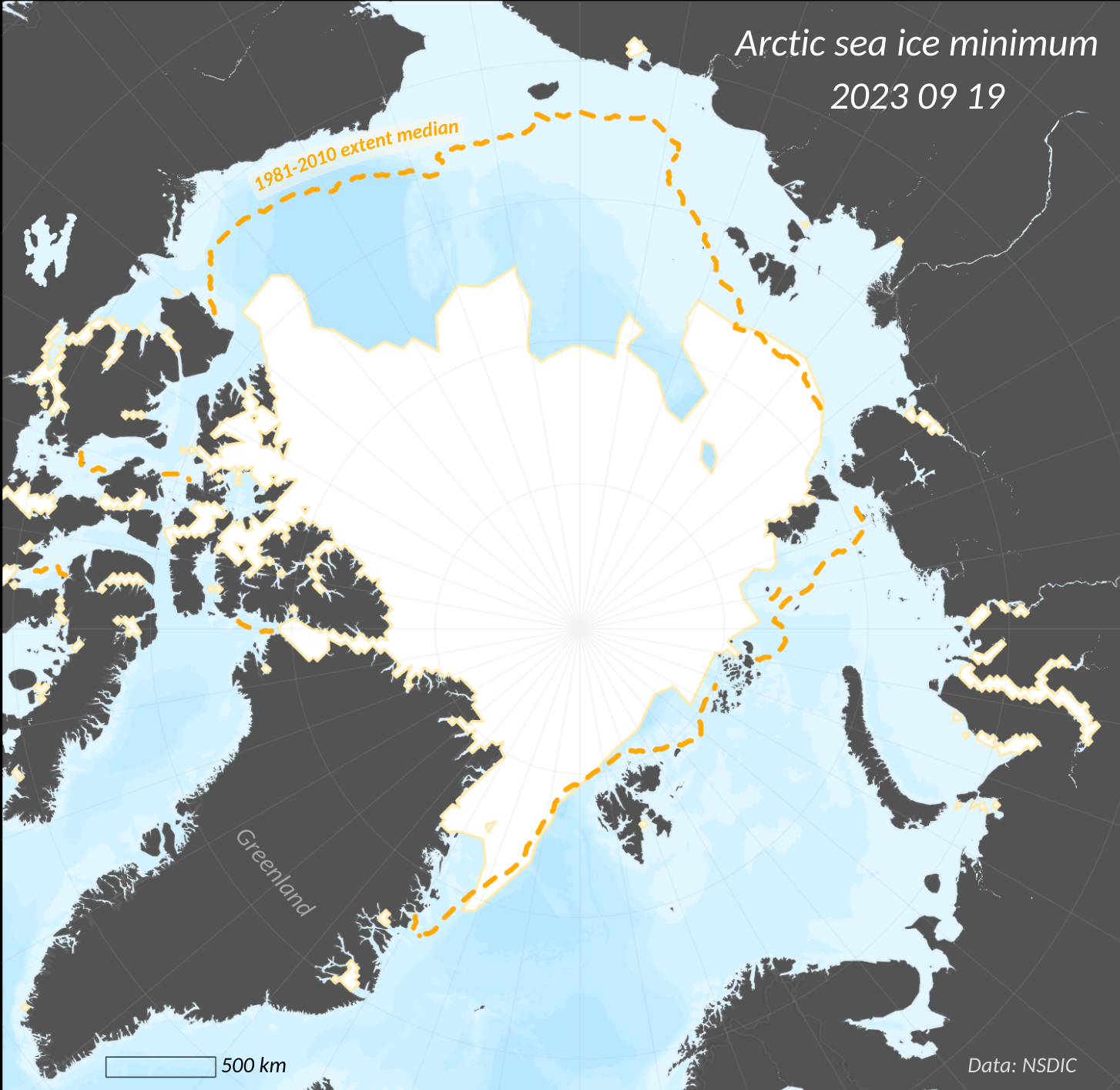
The white area in the provided image marks the minimum extent of Arctic sea ice, while the orange dotted line shows the median extent for 1981–2010. Having compared these boundaries, we can see that sea ice has been shrinking in recent years.
In addition to the above-mentioned record highs, NASA/NOAA VIIRS satellites have also measured more than 18 million hectares of fire-scorched areas in eastern Canada, observed heavy rainfalls in Scandinavia and Alaska, and recorded increasing tundra vegetation dynamics.
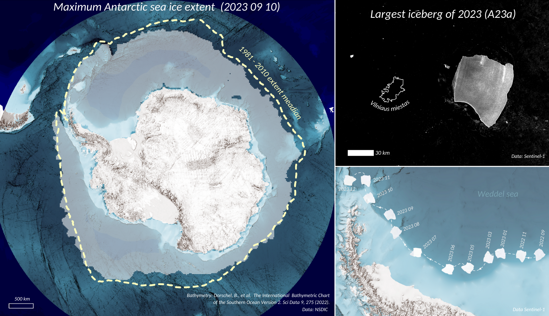
Antarctic sea ice hits record lows, and a giant iceberg breaks off
Sea ice in the Antarctic has also been monitored by radiometers since 1979. The VU geographers provide a satellite-based image depicting the 1981–2010 median extent encircled by a yellow dotted line and the maximum extent for 2023 marked in the whitish colour. Although the melting of Antarctic sea ice is slower than that in the Arctic, the maximum sea ice extent recorded in September 2023 was the lowest since records began.
One of the remote methods for measuring the dimensions of such icebergs and ice-sheet surface elevation changes is radar altimetry. The European Space Agency’s CryoSat-2 satellite has been monitoring polar ice since 2010. The sensor emits microwaves and measures the time it takes for the signal to return from the Earth’s surface. This data is used to determine the distance between the satellite and that specific surface. As measured in mid-December, the iceberg called A23a was 278 meters thick; for comparison, the height of Lithuania’s tallest building – the Television Tower – is 326 meters.
Moreover, global warming has led to an increase in the number of icebergs breaking away from the Antarctic. Currently, the largest iceberg, A23a, covers an expanse of nearly 4,000 square kilometres. Such icebergs are named based on the quadrant of Antarctica from which they calve. A23a split from sector A in the Weddell Sea back in 1986 but got stuck there and started moving faster only in 2020, while at the end of 2023, it began floating away towards the Atlantic Ocean. Its path, shown in the illustration below, can be determined using Sentinel-1 microwave images, which show a stark contrast between the iceberg (white/greyish in colour) and the black water surface.
In this case, breaking off and being carried out into the open ocean waters, the huge iceberg is set to melt and, eventually, disappear. As it moves away from the Antarctic coast to higher latitudes, it will be gradually carried away into saltier, and thus warmer, waters, which will accelerate its melting. In the open ocean, melting ice (which is not only shrinking but also thinning) becomes subject to intense wave action (being washed and cleaved – broken into smaller parts), which, in turn, speeds up melting processes as well. Therefore, according to the geographers, its movement trajectory suggests that this large breakaway iceberg is doomed to disappear entirely in the near future, thus further contributing to the rising ocean levels.