

Satellites Revealed the Extent of the Flooding in the Pamarys Region
Floods in the Pamarys region are nothing new – there are no other places affected by floods in Lithuania as regularly as the Nemunas Delta. Although floods occur every spring in the Pamarys region, some of them are caused by snow melting suddenly, abundant rainfall, periods of thawing, or other factors, and they occur more frequently in winter, too. Therefore, using the data sent by the Sentinel-1 satellite, the geographers of the Faculty of Chemistry and Geosciences of Vilnius University (VU), Elzė Buslavičiūtė and Assoc. Prof. Dr Laurynas Jukna, examine the extent of the flooding and say that the information ascertained from such analysis is useful both for observing changes in natural phenomena and planning new settlements.
More floods are forecast for the future
The total area of the Nemunas Delta is vast, covering 930 square kilometres, and the largest part of it is located in Kaliningrad Oblast. Rising water covers roads and homesteads, complicates communication, and leads to various economic losses in the coastal region. During the cold season of 2023–2024, rivers were flooded in Klaipėda and Šilutė district municipalities several times in mid-November, late December, and late January. During this period, an emergency was declared several times; the response to the latest water rise on 25 January was no exception when Šilutė Municipality declared an emergency in part of its territory due to the extremely high water levels.
However, while the Pamarys region usually faces floods in spring, scientists predict that with global climate change, flooding will also increase in winter: as the frequency of extreme phenomena increases, the dangerous and destructive floods are likely to occur more and more often. The Intergovernmental Panel on Climate Change (IPCC) says that climate change will also increase the extent of floods as rainfall increases. As Lithuania prepares for such threats and implements the Floods Directive adopted by the European Union, digital maps of flood threats and areas at risk of flooding were compiled and updated in 2014.
In general, according to the data of water measurement stations, a decreasing trend of maximum spring flood debits is observed due to less frequent snow cover during the cold season, but the number of floods and subfloods during the winter is increasing. In the future, according to the Environmental Protection Agency’s Flood Risk Management Plan for 2023–2027, the number of floods caused by rain and extreme floods occurring in individual years may increase.
Satellite information – an indispensable tool in the assessment of floods
Since flood areas are often difficult to reach, geographers use ground and satellite data to assess the extent of floods. Water is an exceptional material due to its properties, so a number of methods to observe the surface covered with water have been developed. Water, in liquid form, is good at absorbing near-infrared rays (NIR) at a frequency of 700–1100 nanometres. Since NIR radiation is absorbed by water, only a small portion of it is emitted or reflected back into space. Therefore, if the satellite sensor captures low NIR reflectivity values, this may indicate that the water surface is being captured. Based on this and other characteristics of radiation absorption, various indices have been developed in the field of optical satellite studies, which help to distinguish water bodies or covered areas. However, optical sensors have several shortcomings – for example, they cannot provide any information about the surface if it is cloudy at the time or if the water has covered the bed of a dense forest, which is often the case in Lithuanian conditions.
In such situations, microwave data is used, one of the most important features of which is its ability to penetrate through clouds. The principle of determining water level, in this case, is based not on the rules of the absorption of molecules but rather on the physical laws of reflection. Since the surface of the water is smooth, the microwaves emitted by the satellite bounce back into it like a mirror and are redirected away from the satellite sensor. Therefore, the satellite does not capture any return reflection, and the backscatter values are very low.
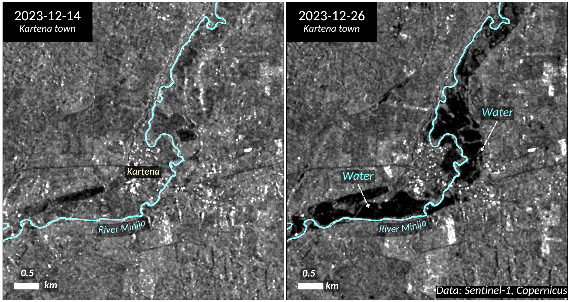
For example, when comparing microwave images of the European Space Agency’s Sentinel-1 satellite from the Kartena area in mid and late December, when the water level had risen, it can be seen that black areas appear around the Minija River, which clearly indicates extremely low reflectivity values, i.e. water surfaces.
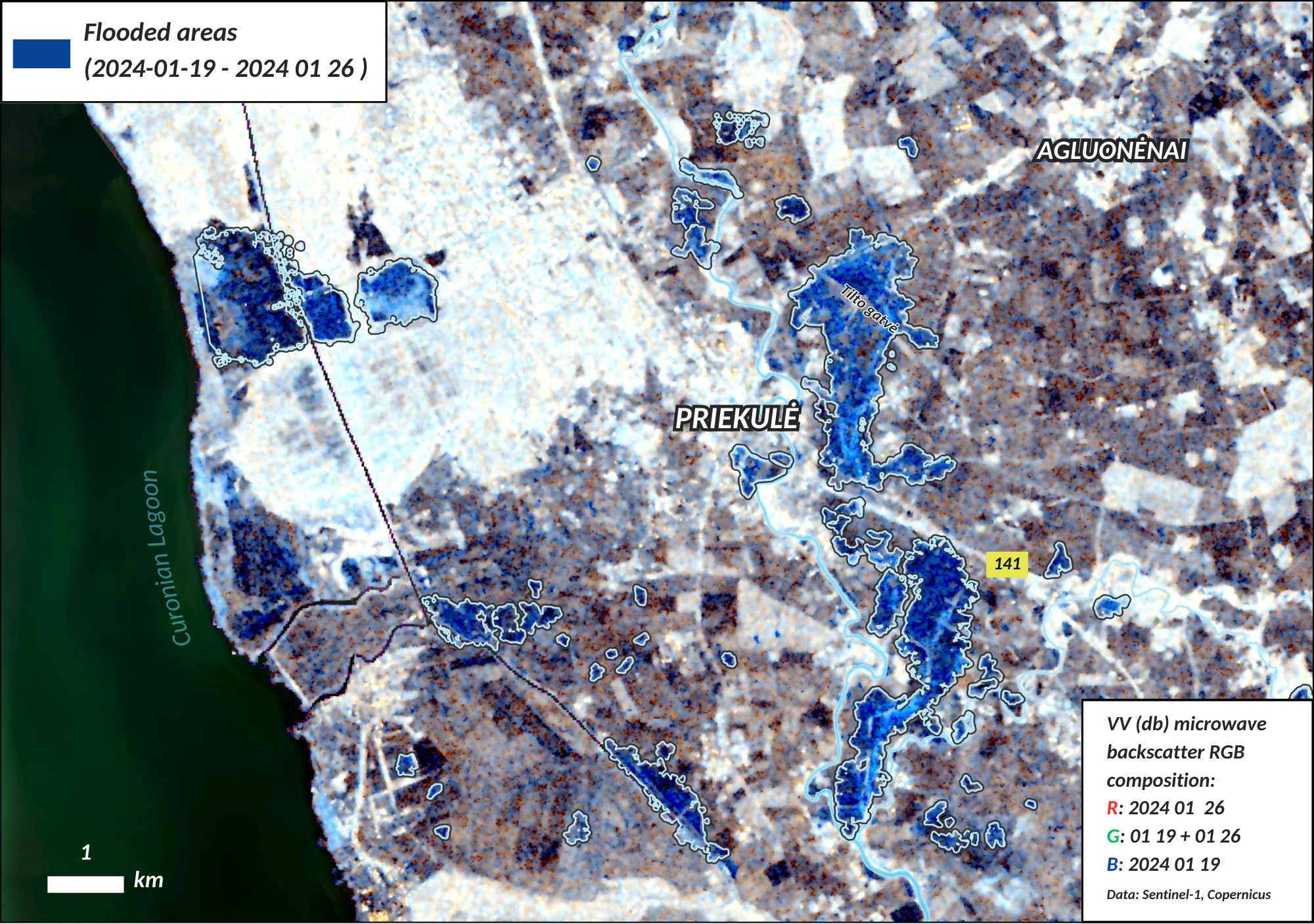
Based on this data, we can determine the area covered in raised water, which infrastructure is at risk, and the time when the water starts to sink. For example, satellite images from 26 January show sections of the Šilutė-Priekulė road (KK141) near Priekulė marked in blue and covered in water due to the high water level. The area in blue is a reflection of the places where the microwave reflectivity values were lower during the flood compared to the ones from 19 January before the water rose. This visual method of combining the images of multiple dates by placing them in our regular RGB (red, green, and blue) image is one of the easiest ways to monitor the dynamics of water level fluctuations. According to the geographers, such a calculation is important not only for recording data but also for planning settlements and infrastructure or providing assistance.
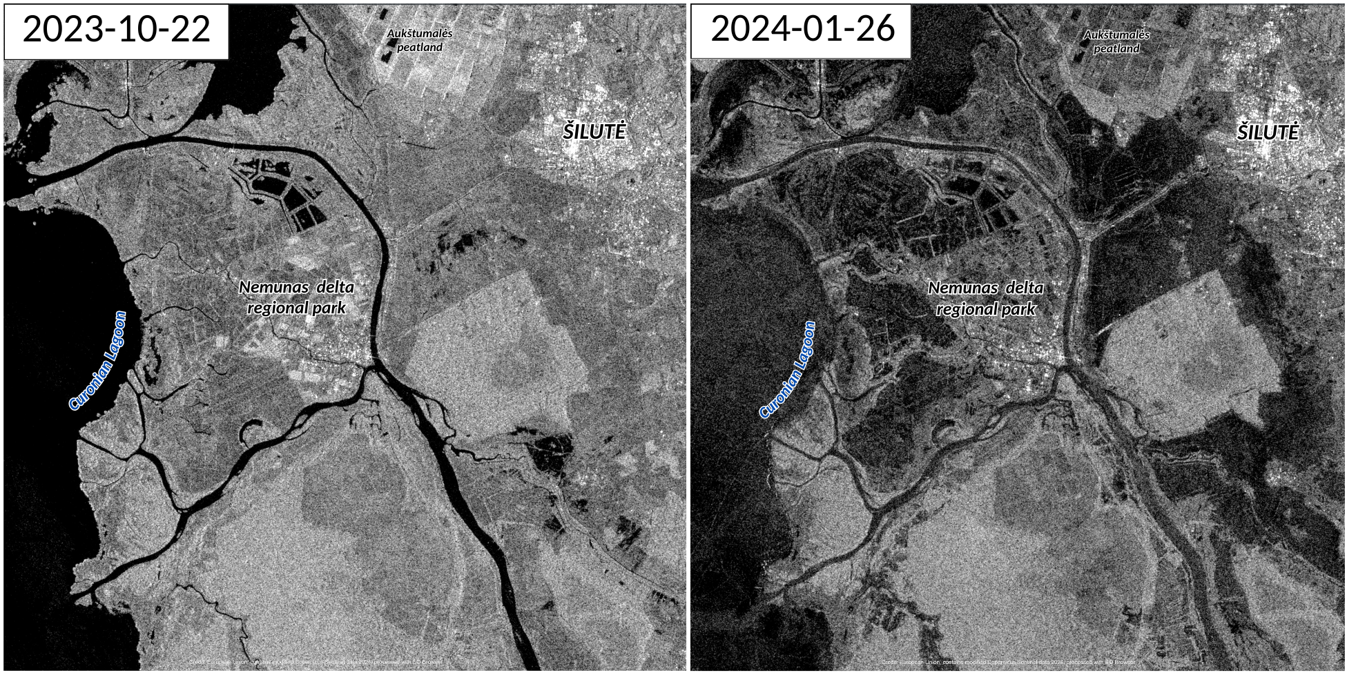
In general, during the last significant increase in the water level in Šilutė District Municipality, almost 13,000 hectares of land were covered by 26 January. In the satellite images of the European Space Agency, we can quickly observe how the area of the flooded (black in photos) territories in the Nemunas Delta and Šilutė area has changed dynamically from October 2023 to January 2024: the brightest part covered in water is around the Žalgiriai forest, where the Atmata River burst its banks.
 Using Sentinel-1 satellite data, geographers can effectively assess the extent of extreme floods and subfloods; moreover, they are better placed to plan settlements and activities in risk areas. For example, using the microwave data of the Sentinel-1 satellites in question, the magnitude of the flooding caused by the collapse of the Kakhovka Dam in Kherson Oblast was rapidly assessed, as well as the extent of the catastrophic floods caused by cyclones such as the Ida that hit southern Africa in 2019, so this type of data is important for assessing the scale of extreme phenomena occurring in both Lithuania and other regions.