

Understanding the Actual Magnitude of Earthquakes in Afghanistan and Morocco
 In September and October, Afghanistan and Morocco were hit by strong earthquakes. In Morocco, where such phenomena are quite uncommon, and in Afghanistan, they wiped out entire villages, killing thousands of people. Using satellite data, Dr Laurynas Jukna and Elzė Buslavičiūtė, geographers at the Institute of Geosciences of Vilnius University (VU), have revealed the actual magnitude of these earthquakes and explained how they can be tracked by employing modern technology.
Satellite-monitored changes
The European Space Agency’s (ESA) Sentinel-1 mission is designed as a two-satellite constellation, where each satellite carries active microwave sensors. These sensors generate and transmit microwave pulses of specific frequencies towards the Earth’s surface. The pulses are then recorded when a portion of the transmitted energy is received as a backscatter from the ground.
Launched in 2014, the Sentinel mission enables all-weather, day-and-night observations of the Earth’s surface – the satellite microwaves penetrate through clouds and the atmosphere, requiring no sunlight. This mission helps geographers and other researchers gather information on ground surface deformations as well as changes in soil moisture and roughness. Such data is actively used to monitor the state of forests, crops, soils, landslides, and surface deformations in active seismic zones and permafrost areas.
One of the most popular methods for monitoring changes in the Earth’s surface is the InSAR – Interferometric Synthetic Aperture Radar. This method relies on phase differences between two radar images. To put it simply, InSAR methods involve a kind of ‘fusion’ – a combination and comparison – of two or more SAR images of the same monitored area. This allows scientists to capture the surface topography or deformations and changes in the Earth’s surface. If the combined SAR images are acquired from slightly different satellite positions, a model of the surface relief of the observed area can be created. In cases when the combined images are captured from the same satellite position but at different time points, the changes in the distance between the time the two radar images were collected will show up as a phase difference, thereby revealing any movements or deformations in the surface.
Morocco’s record-breaking earthquake
Since the SAR method can cover large areas, it is most actively used in monitoring earthquakes and volcanic eruptions, allowing researchers to make more accurate estimations of their magnitude and better understand their causes.
On 8 September, a 6.8 magnitude earthquake struck about 70 km south-west of Marrakesh in Morocco. Its epicentre occurred at a depth of 18.5 km, approximately 550 km north of the African-Eurasian plate boundary. It was the strongest earthquake ever to have hit the country. In Marrakesh, a historic UNESCO heritage site with a population of over 800,000, such tremors are not frequent, and the city’s structures were not resilient enough to withstand the quake, leading to nearly 3,000 fatalities.
During the process of generating interferograms, scientists can not only estimate deformations of the Earth’s surface: an indicator known as coherence also shows the presence or absence of the perturbation of ground scatterers between the two acquisition dates being evaluated. Coherence measures the structure similarity between two identically captured images of the same surface but acquired at different intervals. For example, if buildings collapse or forests are felled, the values of this indicator approach 0, and vice versa: if the surface remains unchanged, the coherence index will be 1. Therefore, taken together, the two images indicate that after an earthquake, where the greatest deformation of the surface occurred, the coherence indicator drops: the darker areas in the images indicate its magnitude.
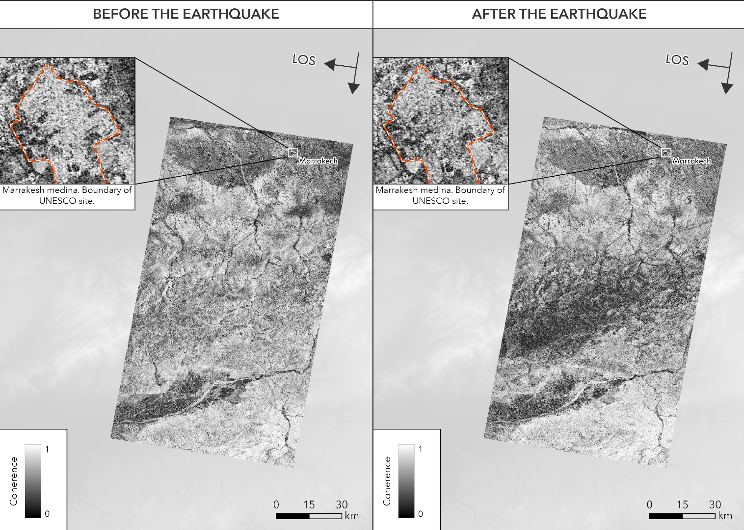
The two provided images show that the coherence index sharply declines where the most significant surface deformation occurs. Looking at Marrakesh in the north of the captured area, we can notice that the coherence index has also decreased, which is usually an indication of destroyed and damaged buildings in urban areas.
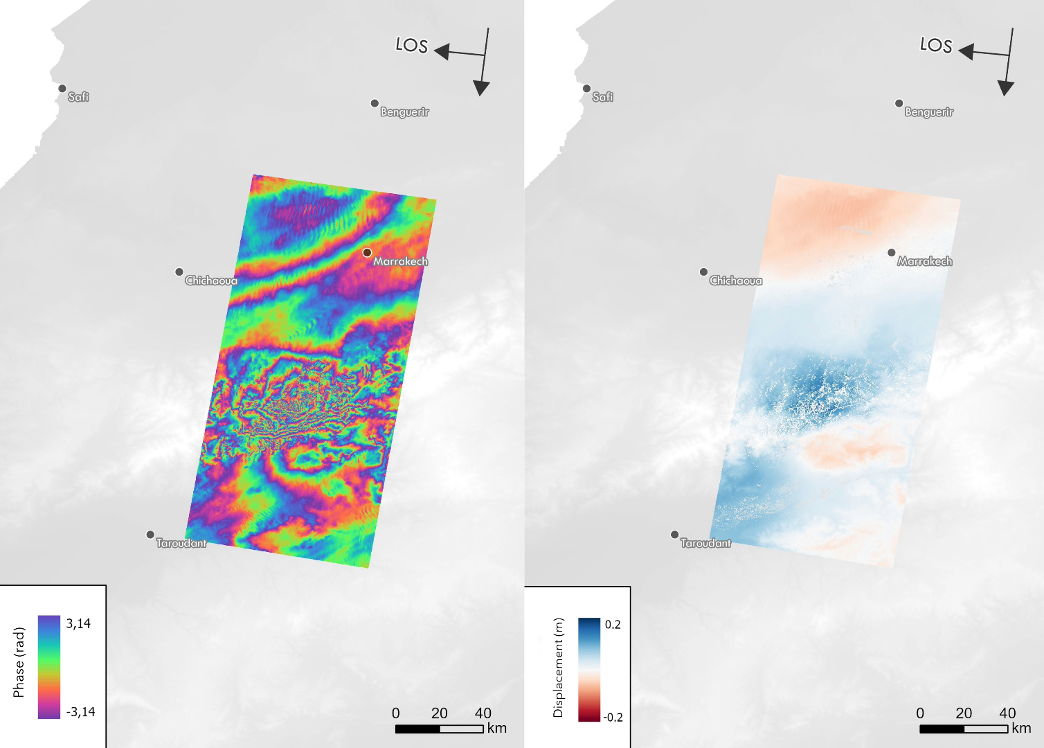
The satellite-based images also show the deformation of the surface between 30 August 2023 and 11 September 2023. The colour sequence from blue to purple points to a ~3 cm deformation in the line-of-sight (LOS) direction. As can be seen from the images, the maximum deformation near the epicentre reaches 20 cm.
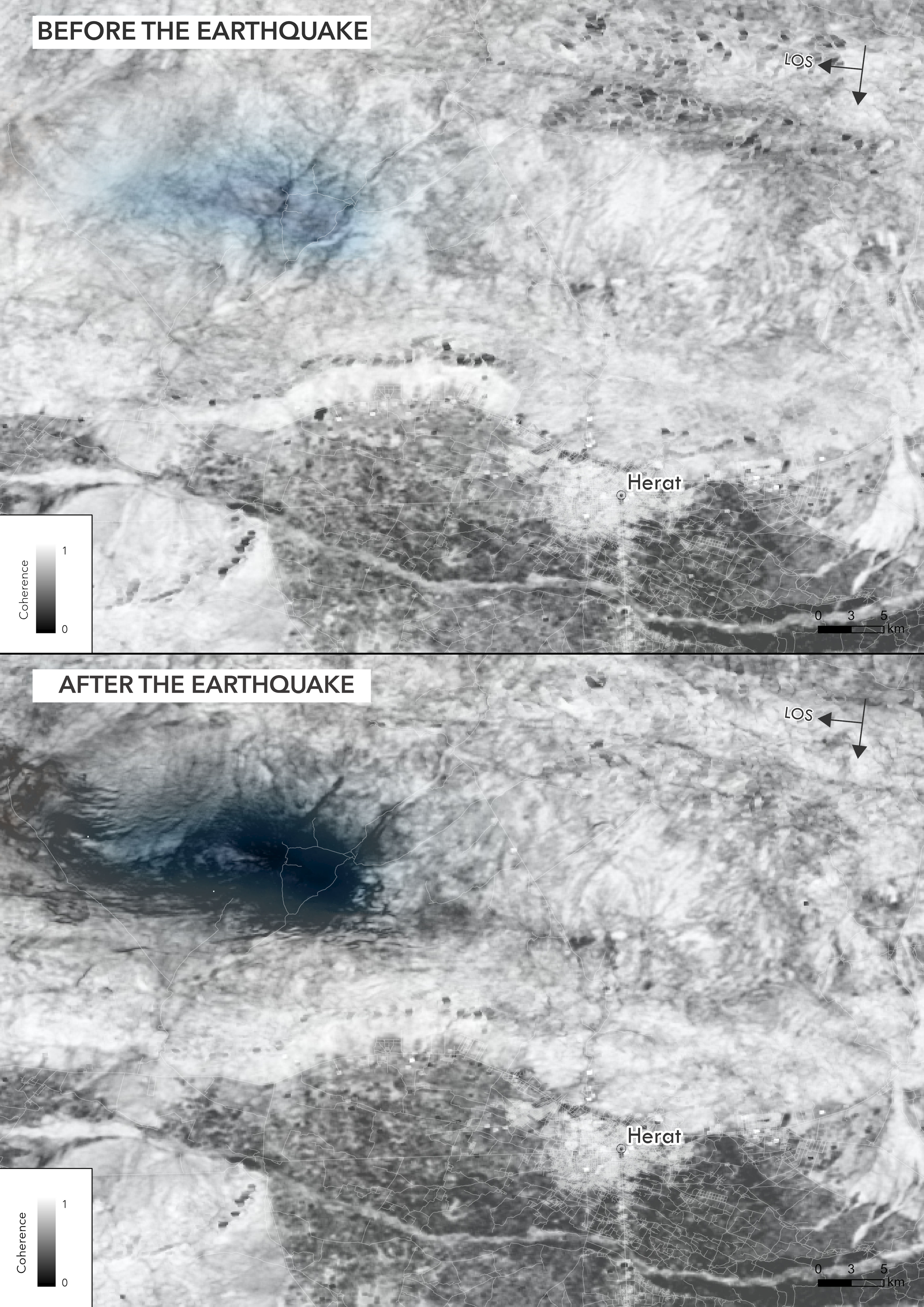
Afghanistan faced one of the strongest earthquakes of 2023
On 7 October 2023, a powerful 6.3 magnitude earthquake hit north-western Afghanistan, with its epicentre about 40 km north-west of Herat, home to more than half a million people. The tremor was also felt in the nearby provinces of Badghis and Farah. It was one of the deadliest earthquakes this year, after the ones in Turkey and Syria that killed around 50,000 people in February 2023.
 The Herat Province is located close to the junction of the Arabian, Indian, and Eurasian plates, which means that earthquakes are quite common in this region. In western and central Afghanistan, it is the northward movement of the Arabian Plate that has the greatest impact.
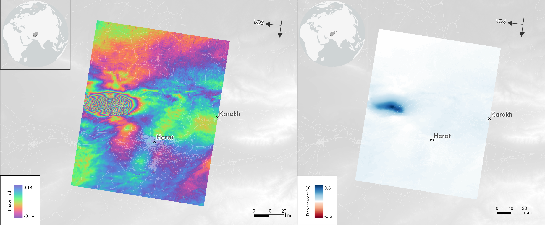
On 8 October, the morning after the earthquake, the Sentinel-1 satellite data was made available for this area. The images showed the deformation of the surface between 26 September 2023 and 8 October 2023. The sequence of colours from blue to purple points to a ~3 cm deformation in the satellite LOS direction. The darker the colour, the more severe the deformation; thus, we can see the densification of these fringes near the epicentre. In the blue area, the maximum deformation close to the epicentre reaches 60 cm in the satellite LOS direction.
Turkey, Morocco, and Afghanistan are just a few countries that have been hit by severe earthquakes this year, claiming heavy casualties. Another area currently under close observation is the Phelegraean Fields – a volcanic area in Italy near Naples, where intense crustal changes have recently been recorded.