“VU Experts Help Understand”: Satellite Images Reveal the Extent of Destruction in Gaza
In the age of open data, with satellite technology having revolutionised the monitoring of military operations and conflict regions, previously limited information has now become readily available. Near real-time, high- and medium-resolution satellite images are used not only for intelligence purposes but also for countering widespread disinformation. Elzė Buslavičiūtė and Dr Laurynas Jukna, geographers from the Faculty of Chemistry and Geosciences of Vilnius University (VU), explain what satellite data can tell us about the current conflict in the Gaza Strip.
Images capturing the course of the war from its very first hours
Assessing war-related destruction in areas of active hostilities is a complex and dangerous task, which is why remote sensing is being increasingly used for determining the initial extent of damage (inflicted to infrastructure, property, natural environment, etc.) and for planning humanitarian aid. On the morning of 7 October, Hamas terrorists attacked Israel from the Gaza Strip. According to estimates, more than 1,400 people were killed, 5,600 wounded, and more than 240 hostages were taken. In response to these attacks, Israel officially declared war (for the first time since 1973), and the country’s military launched “Operation Swords of Iron”, aimed at countering the threat posed by Hamas and destroying the terrorist organisation itself.
Currently, Israel is in a particularly difficult situation, as the anti-Hamas operation is mainly being carried out in the densely-populated Palestinian Gaza Strip, and the organisation’s fighters often use civilian infrastructure and peaceful population as cover for their military actions. A few hours after the first Hamas attack began, the Sentinel-2 satellite passed over Israel and Gaza, taking what was probably the first publicly available satellite images to capture the onset of this war. They depict smoke and areas of active hostilities in Israeli settlements close to the Gaza Strip, including the heavily affected Kfar Aza, Be’eri, and others.
Microwave frequencies facilitate conflict monitoring
In addition to conventional optical images, satellites also observe the Earth at microwave frequencies. For example, satellite radar data is used in InSAR (Interferometric Synthetic Aperture Radar) data processing. According to the geographers, although this type of remote sensing is most often used for monitoring earthquakes and surface deformations, it is increasingly applied to military conflict zones as well. The coherence index measuring changes in the scattering properties of the land surface has been repeatedly used to assess the damage caused to infrastructure in such Ukrainian cities as Mariupol. One of the indices used for initial damage assessment where ground-based data is not available is the DPNCI (Dual-Polarisation Normalised Coherence Index). It uses coherence data of different polarisations and allows researchers to evaluate the degree of damage in urban zones – to ascertain whether it is severe, moderate, or if a certain area has not been affected at all.
The DPNCI for the period from 7 October to 18 November in Gaza shows large-scale destruction of infrastructure, with the greatest damage seen in the northern part of its territory. The data shows that around 44,000 constructions north of the Wadi Gaza border have been destroyed or severely damaged. Based on the OpenStreetMap (OSM) geospatial dataset, it accounts for more than half of all buildings in northern Gaza.
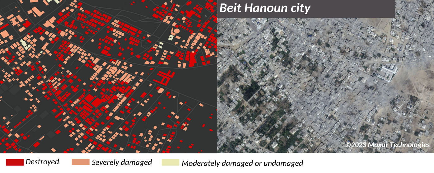
Referring to the data provided by the Palestinian Ministry of Public Works and Housing, the United Nations (UN) Office for the Coordination of Humanitarian Affairs (OCHA) states that at least 45 per cent of all buildings in the Gaza Strip have already been destroyed or affected since early October. The worst impact can be seen in Beit Hanoun in the northern part of Gaza, as well as in the Al-Shati refugee camp located along the Mediterranean Sea coastline in the western part of the Gaza Strip. Based on the microwave data from Sentinel-1, which has also been used by the VU geographers, other researchers suggest that at least 50 per cent of all buildings north of the Wadi Gaza evacuation line have been destroyed or damaged.
High-resolution images ensure accurate damage assessment
While remote sensing-based damage assessments cannot substitute on-site evaluations of the destruction of buildings (e.g. in Mariupol, Ukraine, the accuracy of DPNCI reached 70 per cent), it still can help summarise the extent of inflicted damage and identify the most affected areas. The availability of high-resolution images of such sites as the Al Gharbi and Yassin mosques or the city of Beit Hanoun may facilitate assessing the accuracy of these calculations.
According to the researchers, the use of optical and microwave satellite data in conflict zones has become increasingly important in recent years. For instance, it proved to be invaluable in monitoring the impact of the Kakhovka Dam collapse in the Kherson region, as well as other hostilities in Ukrainian cities, Syria, and Iraq.
Open access to this data helps fight disinformation and ensures a better public understanding of the processes occurring in conflict zones.
The VU geographers illustrate the importance of satellite- and ground-based data in warfare by providing an example of the way terrorist organisations treat the civilian population and potential victims of their actions: one of the leaders of Hamas, Mousa Abu Marzouk, was asked in a 2023 interview why 500 kilometres of tunnels had been built by Hamas, mainly in the Gaza territory, which it has controlled since 2007, yet it has never built civilian bomb shelters. He said, “We built the tunnels because we (Hamas) have no other way of protecting ourselves from being killed in airstrikes. We are fighting from inside the tunnels. (…) 75 per cent of Gaza’s population are refugees, and it is the UN’s responsibility to protect them (not ours).”