- 30 September 2026
- Kornelija Kamaitytė
Satellite Data Reveal Contrasting Post-Fire Recovery on the Curonian Spit and Kinburn Peninsula

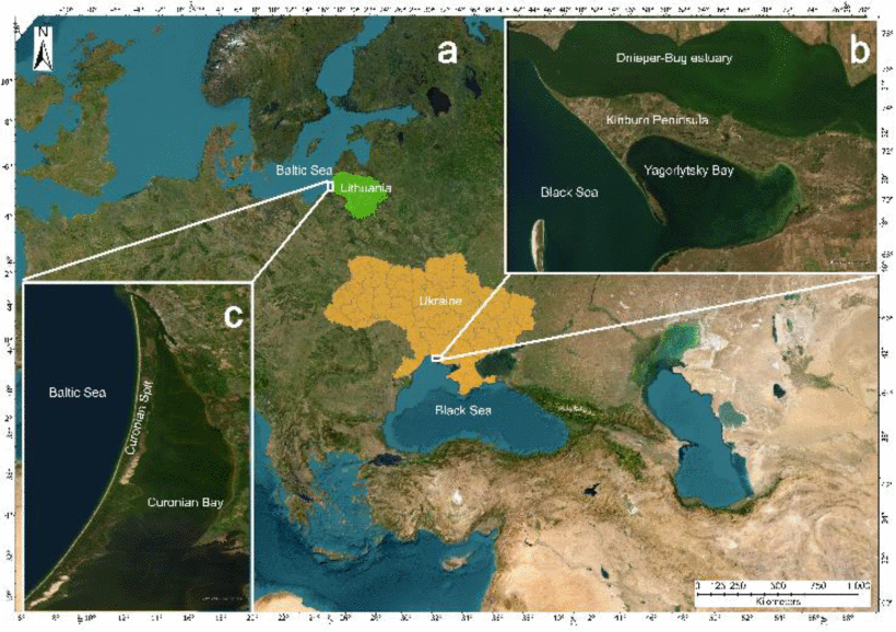
How do sandy coastal ecosystems recover after major wildfires, and does a landscape turning green again really mean that nature has recovered? Researchers from Vilnius University (VU) and the Nature Research Centre (NRC) used long-term satellite data to compare fire-affected areas on the Curonian Spit in Lithuania and the Kinburn Peninsula in Ukraine. The study published in the IEEE Journal of Selected Topics in Applied Earth Observations and Remote Sensing, revealed striking differences in the recovery of these areas.
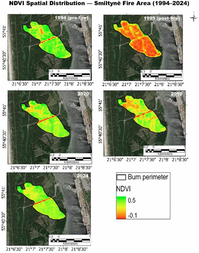
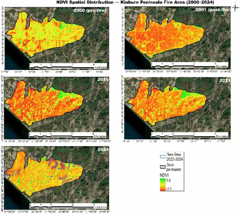
In Smiltynė, following the 1995 fire, vegetation productivity not only recovered but exceeded pre-fire levels within approximately 20–25 years. On the Kinburn Peninsula, meanwhile, vegetation recovery remained incomplete even more than two decades after the 2001 fire.
A Green Landscape Does Not Necessarily Mean a Recovered Ecosystem
“The condition of a fire-affected ecosystem cannot be assessed simply by whether vegetation has reappeared in the area. Satellite indicators make it possible to determine whether the previous productive forest ecosystem is being restored or whether it is being replaced by sparser, less productive plant communities,” says study co-author Dr Linas Bevainis, Associate Professor at the Department of Cartography and Geoinformatics, Institute of Geosciences, Faculty of Chemistry and Geosciences, VU.
The study showed that ecosystem recovery depends on more than just the time elapsed since a fire. Climatic conditions, moisture levels, repeated disturbances and human-led restoration measures all play a significant role.
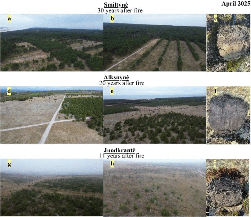
On the wetter Curonian Spit, where forest restoration was carried out after the fires, recovery was faster and more successful. On the drier Kinburn Peninsula, it was constrained by lower rainfall, repeated fires and weaker natural regeneration potential.
“A landscape turning green after a fire does not necessarily mean that the ecosystem has fully recovered. Only long-term monitoring can show whether it is truly returning to its previous state or shifting towards a different, less productive one,” emphasises Dr Bevainis.
The study drew on long-term Landsat and more recent Sentinel-2 satellite image time series, together with several indicators describing vegetation condition. Combining these data allowed the researchers to assess not only the extent of vegetation recovery but also its stability and long-term trajectory.
Using several different indicators is particularly important when studying sandy areas. Exposed soil and sand can distort the values of individual vegetation indices, so combining multiple indices provides a more reliable assessment of the ecosystem’s actual condition.
A Marked Change on the Kinburn Peninsula after 2022
One of the most notable changes identified in the study was observed on the Kinburn Peninsula. Satellite data showed that between 2022 and 2024, following an earlier period of relative stabilisation, vegetation condition began to deteriorate.
This period coincides with intense wartime activity in the region, changes in land use, recurring fires and the disruption of routine environmental management. Nevertheless, the researchers stress that satellite data alone are insufficient to establish a direct causal link between the war and the deterioration of the ecosystem.
“It is scientifically more accurate to say that the observed deterioration coincides, in time and space, with increased anthropogenic pressure during the war. To distinguish more precisely between the effects of war, fires, drought and other factors, additional higher-spatial-resolution data, information on specific disturbances and field studies, once they can be conducted safely, would be needed,” explains Dr Bevainis.
Satellites Make It Possible to Monitor Even Hard-to-Reach Areas
The methodology applied in the study can also be used for the long-term monitoring of other fire-affected areas. It makes it possible to determine the area affected by fire and the severity of the damage, track the pace of vegetation recovery, compare it with pre-fire conditions and detect whether recovery has stalled or degradation has begun.
This type of monitoring is particularly useful across large areas that are difficult to reach or inaccessible for safety reasons. The study’s results can help identify locations where active forest restoration, additional protection or more detailed field studies are needed. Repeating the analysis regularly can also help assess the effectiveness of conservation measures.
Could Help Monitor Other Fire-Affected Areas
The study was conducted by Yuliia Shevchuk, a doctoral student at the Nature Research Centre, NRC researcher Dr Oleksiy Davydov and VU Associate Professor Dr Linas Bevainis.
Dr Bevainis is Shevchuk’s doctoral supervisor, while Dr Davydov is her consultant at the NRC. According to the VU researcher, one of the key directions of the study was to bring data from the Kinburn Peninsula and the Curonian Spit together in a single, methodologically comparable analysis.
“This publication shows how the expertise accumulated at VU in remote sensing, cartography and geoinformatics can be applied to address environmental monitoring challenges of international relevance. At the same time, it is the result of successful collaboration between VU and NRC and between Lithuanian and Ukrainian researchers,” says Dr Bevainis.